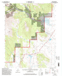
1994 Map of Como
USGS Topo · Published 1998About this map
Como anchors this high-elevation landscape in South Park, where the remnants of mining and ranching history are deeply etched into the mountain terrain. This 1994 revision, based on mid-century topography and late-1980s imagery, documents a transition from active industry to historical sites. The extraction of minerals is marked by the Silverheels Mine and the Fortune Placer Mine, while the agricultural footprint is preserved through family holdings like the Robinson Ranch and Eightmile Ranch. Much of the northern terrain falls within the Pike National Forest, where the Gold Dust Trail and Boreas Pass Road follow natural contours through gulches such as Deadwood Gulch and Montgomery Gulch. Former civic life is represented by several inactive locations, including the Fremont Sch (Site) and the Hamilton (Site) settlement, offering a clear record of the area's shifting population centers over the decades.
Find a feature on this map
39 named features on this map. Tap any name to fly to it.
Don’t see what you’re looking for? This feature index may not catch every label — zoom into the map to look around manually.
Map Details
Editions of this 1994 Como Map
This is the sole edition of this map. No revisions or reprints were ever made.
Other maps of this area

1889 · Leadville
USGS Topo · 1:125,000

1891 · Leadville
USGS Topo · 1:125,000

1934 · Climax
USGS Topo · 1:48,000

1937 · Como
USGS Topo · 1:62,500

1938 · Mt. Lincoln
USGS Topo · 1:48,000

1942 · Leadville
USGS Topo · 1:125,000

1945 · Mount Lincoln
USGS Topo · 1:62,500

1953 · Denver
USGS Topo · 1:250,000

1956 · Elkhorn
USGS Topo · 1:24,000

1956 · Fairplay East
USGS Topo · 1:24,000