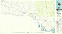
1985 Map of Comstock
USGS Topo · Published 1986About this map
The Rio Grande and the lower Pecos River carve deep canyons through this portion of Val Verde County, defining a landscape shaped by water and transport. During the mid-1980s, the Amistad Reservoir dominated the southeastern corner, its fingers reaching up Evans Creek and the Devils River. The Southern Pacific railroad line parallels Highway 90, connecting a series of isolated stations and outposts like Pumpville, Lozier, and Langtry. Evidence of early human habitation and natural formations are noted at Big Tree Cave and Emerald Cave, while Seminole Canyon State Historical Park preserves the cultural heritage of the limestone bluffs. The map captures the infrastructure of the borderlands, from the International Jurisdictional Line to remote water tanks and landing strips that served the sprawling ranchlands and canyon country of West Texas.
Find a feature on this map
72 named features on this map. Tap any name to fly to it.
Don’t see what you’re looking for? This feature index may not catch every label — zoom into the map to look around manually.
Map Details
Editions of this 1985 Comstock Map
2 editions found
Other maps of this area

1918 · Dryden Crossing
USGS Topo · 1:62,500

1928 · Sanderson
USGS Topo · 1:125,000

1941 · Feely
USGS Topo · 1:62,500

1943 · Malvado
USGS Topo · 1:62,500

1943 · Devils River
USGS Topo · 1:62,500

1943 · Langtry
USGS Topo · 1:62,500

1943 · Del Rio
USGS Topo · 1:62,500

1943 · Shumla
USGS Topo · 1:62,500

1944 · Devils River
USGS Topo · 1:62,500

1944 · Mouth Of Pecos
USGS Topo · 1:62,500