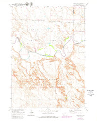
1952 Map of Conata NE
USGS Topo · Published 1979About this map
The Pine Ridge Indian Reservation dominates the southern landscape of this mid-century survey, defined by the winding course of the White River. The river forms a natural divide between the reservation land and the northern plains where the Chicago Milwaukee St Paul and Pacific railroad tracks cut a straight path across the terrain. This map captures the region as it transitioned through late-1970s updates based on 1948 and 1976 aerial photography, showing the intricate topography of the Castle Butte area and the northern edge of the Badlands National Monument. Small-scale features such as a Gravel Pit and a remote Spring indicate localized land use, while the Reservation Boundary and various county lines between Jackson, Pennington, and Washabaugh reflect the administrative layout of this Dakota landscape before later jurisdictional shifts.
Find a feature on this map
12 named features on this map. Tap any name to fly to it.
Don’t see what you’re looking for? This feature index may not catch every label — zoom into the map to look around manually.
Map Details
Editions of this 1952 Conata NE Map
2 editions found
Other maps of this area

1950 · Conata
USGS Topo · 1:24,000

1950 · Interior
USGS Topo · 1:24,000

1950 · Conata SW
USGS Topo · 1:24,000

1950 · Potato Creek
USGS Topo · 1:24,000

1952 · Conata NE
USGS Topo · 1:24,000

1952 · Conata SE
USGS Topo · 1:24,000

1952 · Conata
USGS Topo · 1:24,000

1955 · Hot Springs
USGS Topo · 1:250,000

1955 · Martin
USGS Topo · 1:250,000

1958 · Martin
USGS Topo · 1:250,000