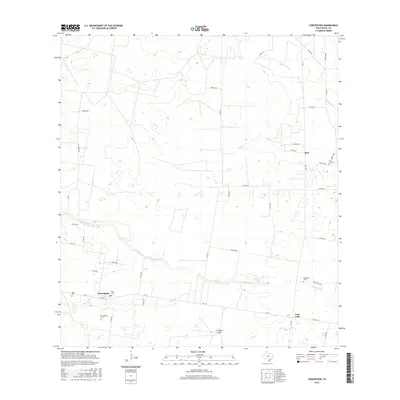
2016 Map of Concepcion
USGS Topo · Published 2016About this map
Concepcion and the neighboring small communities of Rios and Cruz Calle anchor this southern Duval County landscape, where the brush country of the Rio Grande Plain meets a network of ephemeral waterways. The geography is defined by the winding paths of Los Olmos Cr, Macho Cr, and Jaboncillos Cr, which trace through a terrain of large private holdings and ranching infrastructure. For genealogists, the map is particularly detailed regarding local family burial sites, documenting Concepcion Cem, Velas Cem, Perez Cem, Gonzales Cem, and Vera Cruz Cem scattered across the countryside. Long-established property boundaries are noted by recurring Fence Line markers, while transportation is facilitated by rural farm-to-market roads and the 4-G Ranch Airport, reflecting the area's continued reliance on livestock and traditional land use in the 21st century.
Find a feature on this map
40 named features on this map. Tap any name to fly to it.
Don’t see what you’re looking for? This feature index may not catch every label — zoom into the map to look around manually.
Map Details
Editions of this 2016 Concepcion Map
This is the sole edition of this map. No revisions or reprints were ever made.
Other maps of this area

1917 · Ben Bolt
USGS Topo · 1:62,500

1921 · Falfurrias
USGS Topo · 1:125,000

1956 · Benavides
USGS Topo · 1:62,500

1956 · Laredo
USGS Topo · 1:250,000

1963 · Premont West
USGS Topo · 1:24,000
1963 · Palito Blanco
USGS Topo · 1:24,000
1963 · Seeligson Ranch
USGS Topo · 1:24,000

1968 · Concepcion
USGS Topo · 1:24,000

1968 · San Jose
USGS Topo · 1:24,000

1968 · Benavides
USGS Topo · 1:24,000