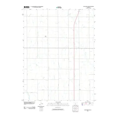
2009 Map of Concordia NW
USGS Topo · Published 2009About this map
The Republican River cuts across the southwestern corner of this Cloud County landscape, defining a rural territory structured by a precise grid of sectional roads. This 2009 survey reveals a strictly agricultural environment where small drainages like East Creek, West Creek, and Grave Creek weave through the fields toward larger valley systems. The human footprint is most evident in the preservation of local heritage sites, specifically the Pleasant Ridge Cemetery and Saron Cemetery, which serve as quiet markers of the families who settled this prairie. A network of local thoroughfares, including Wagon Rd, Vista Rd, and Co Line Rd, facilitates movement across the vast stretches of farmland between these historic burial grounds and the wandering paths of Hay Creek and Cool Creek.
Find a feature on this map
24 named features on this map. Tap any name to fly to it.
Don’t see what you’re looking for? This feature index may not catch every label — zoom into the map to look around manually.
Map Details
Editions of this 2009 Concordia NW Map
This is the sole edition of this map. No revisions or reprints were ever made.
Other maps of this area

1892 · Concordia
USGS Topo · 1:125,000

1955 · Manhattan
USGS Topo · 1:250,000

1956 · Manhattan
USGS Topo · 1:250,000

1957 · Manhattan
USGS Topo · 1:250,000

1965 · Wayne
USGS Topo · 1:24,000

1965 · Concordia NW
USGS Topo · 1:24,000
1965 · Rice
USGS Topo · 1:24,000
1965 · Concordia
USGS Topo · 1:24,000

1965 · Kackley
USGS Topo · 1:24,000

1966 · Scandia
USGS Topo · 1:24,000