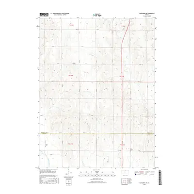
2015 Map of Concordia NW
USGS Topo · Published 2015About this map
Cloud County and Republic County are divided here by the Co Line Rd, where the landscape transitions into the fertile bottomlands of the Republican River. This 2015 survey reveals a terrain defined by rolling agricultural divides and the drainage systems of Grave Cr, Hay Cr, and Cool Cr. For genealogists and local historians, several small burial sites serve as landmarks of early settlement, including the Pleasant Ridge Cem in the north and the Dutton Family Cem near the river's path. The junction of highway 81 and route 148 provides the primary transit corridor through this rural landscape, passing by the Saron Lutheran Cem and Murdock Cem, which sit amidst the section-line road network that has structured this prairie region for over a century.
Find a feature on this map
30 named features on this map. Tap any name to fly to it.
Don’t see what you’re looking for? This feature index may not catch every label — zoom into the map to look around manually.
Map Details
Editions of this 2015 Concordia NW Map
This is the sole edition of this map. No revisions or reprints were ever made.
Other maps of this area

1892 · Concordia
USGS Topo · 1:125,000

1955 · Manhattan
USGS Topo · 1:250,000

1956 · Manhattan
USGS Topo · 1:250,000

1957 · Manhattan
USGS Topo · 1:250,000

1965 · Wayne
USGS Topo · 1:24,000

1965 · Concordia NW
USGS Topo · 1:24,000
1965 · Rice
USGS Topo · 1:24,000
1965 · Concordia
USGS Topo · 1:24,000

1965 · Kackley
USGS Topo · 1:24,000

1966 · Scandia
USGS Topo · 1:24,000