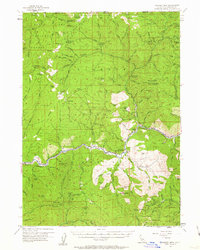
1955 Map of Condrey Mtn
USGS Topo · Published 1963About this map
The Klamath River carves a deep valley through the heart of the Klamath National Forest in this mid-century portrait of Siskiyou County. The landscape is defined by its rugged isolation and a long-standing mining economy, evidenced by scattered operations like the Penn Mine and Cinnabar Mine. Local life centers on the river corridor, where the Klamath River School and Klamath River P O served a sparse population of ranchers and woodsmen. Higher elevations reveal a network of lookouts and camps, including the Deadwood Lookout and Buckhorn Camp, which were vital for forest management. Along the northern border, the Rogue River National Forest transition is marked by notable features such as Donomore Meadows and the high peak of Condrey Mtn. This map captures a moment when the region relied heavily on seasonal camps and remote stations like the Oak Knoll Ranger Sta to navigate its formidable terrain.
Find a feature on this map
81 named features on this map. Tap any name to fly to it.
Don’t see what you’re looking for? This feature index may not catch every label — zoom into the map to look around manually.
Map Details
Editions of this 1955 Condrey Mtn Map
3 editions found

Other maps of this area

1886 · Shasta
USGS Topo · 1:250,000

1891 · Ashland
USGS Topo · 1:250,000

1893 · Ashland
USGS Topo · 1:250,000

1894 · Shasta
USGS Topo · 1:250,000

1897 · Ashland
USGS Topo · 1:250,000

1908 · Grants Pass
USGS Topo · 1:125,000

1914 · Seiad
USGS Topo · 1:125,000

1922 · Seiad
USGS Topo · 1:125,000

1932 · Yreka
USGS Topo · 1:96,000

1938 · Medford
USGS Topo · 1:125,000