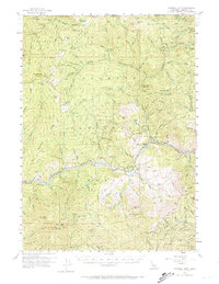
1955 Map of Condrey Mtn
USGS Topo · Published 1974About this map
The Klamath River carves a deep path through this mid-century landscape where the border between Rogue River National Forest and Klamath National Forest meets at the Oregon-California line. The terrain is defined by a series of working claims and historical mining sites, including the Cinnabar Mine and the Commodore Mine, reflecting the region's enduring extraction history. The Oak Knoll Ranger Sta and Klamath River School serve as local anchors along the river corridor.
Find a feature on this map
92 named features on this map. Tap any name to fly to it.
Don’t see what you’re looking for? This feature index may not catch every label — zoom into the map to look around manually.
Map Details
Editions of this 1955 Condrey Mtn Map
3 editions found

Other maps of this area

1886 · Shasta
USGS Topo · 1:250,000

1891 · Ashland
USGS Topo · 1:250,000

1893 · Ashland
USGS Topo · 1:250,000

1894 · Shasta
USGS Topo · 1:250,000

1897 · Ashland
USGS Topo · 1:250,000

1908 · Grants Pass
USGS Topo · 1:125,000

1914 · Seiad
USGS Topo · 1:125,000

1922 · Seiad
USGS Topo · 1:125,000

1932 · Yreka
USGS Topo · 1:96,000

1938 · Medford
USGS Topo · 1:125,000