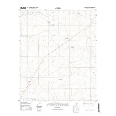
2013 Map of Conejo Creek West
USGS Topo · Published 2013About this map
Stevens Ranch and Trigg Ranch anchor this high-plains landscape in De Baca County, illustrating the persistence of livestock operations in the eastern New Mexico grasslands. The terrain is defined by the drainage patterns of Little Conejo Creek and the broader Conejo Basin, which carve subtle relief across the plains. These watercourses are vital lifelines in an arid environment, supported by a network of named water sources such as Conejo Spring, Mum Spring, and Shaw Spring.
Find a feature on this map
25 named features on this map. Tap any name to fly to it.
Don’t see what you’re looking for? This feature index may not catch every label — zoom into the map to look around manually.
Map Details
Editions of this 2013 Conejo Creek West Map
This is the sole edition of this map. No revisions or reprints were ever made.
Other maps of this area

1954 · Fort Sumner
USGS Topo · 1:250,000

1958 · Fort Sumner
USGS Topo · 1:250,000

1966 · West Camp
USGS Topo · 1:24,000

1966 · Alamo Ranch
USGS Topo · 1:24,000

1966 · Horney Ranch
USGS Topo · 1:24,000

1967 · Dunlap NE
USGS Topo · 1:24,000

1967 · Conejo Creek West
USGS Topo · 1:24,000
1967 · Lovelady Draw
USGS Topo · 1:24,000
1967 · Dunlap
USGS Topo · 1:24,000
1967 · La Espia Peak
USGS Topo · 1:24,000