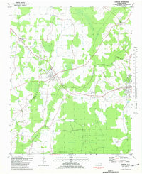
1981 Map of Conetoe
USGS Topo · Published 1981About this map
Conetoe and Bethel anchor this agricultural and swamp-rich landscape along the border of Edgecombe and Pitt counties. The terrain is defined by the significant wetlands of the Grindle Pocosin and Mitchell Swamp, which are crossed by an intricate network of drainage features like the Lewis Canal and Ballahack. This era of the late 1970s and early 1980s shows a region deeply connected by the Seaboard Coast Line railroad, which services the small rural settlements and provides a clear transport corridor through the pocosin. For those researching local family history, the map provides precise locations for numerous rural cemeteries, labeled simply as Cem, as well as Johnson Ch and smaller crossroads communities like Dogtown, Mildred, and Mayos Crossroads. The distribution of these sites across the low-lying creeks, including Conetoe Creek and Grindle Creek, illustrates the long-standing settlement patterns of the North Carolina coastal plain.
Find a feature on this map
19 named features on this map. Tap any name to fly to it.
Don’t see what you’re looking for? This feature index may not catch every label — zoom into the map to look around manually.
Map Details
Editions of this 1981 Conetoe Map
This is the sole edition of this map. No revisions or reprints were ever made.
Other maps of this area

1901 · Parmele
USGS Topo · 1:62,500

1902 · Parmele
USGS Topo · 1:62,500

1902 · Tarboro
USGS Topo · 1:62,500

1903 · Tarboro
USGS Topo · 1:62,500

1903 · Winterville
USGS Topo · 1:62,500

1904 · Falkland
USGS Topo · 1:62,500

1905 · Winterville
USGS Topo · 1:62,500

1953 · Rocky Mount
USGS Topo · 1:250,000

1954 · Rocky Mount
USGS Topo · 1:250,000

1980 · Falkland
USGS Topo · 1:24,000