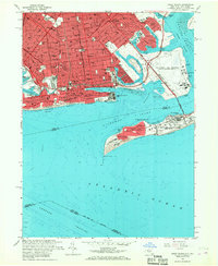
1966 Map of Coney Island
USGS Topo · Published 1968About this map
Coney Island and the southern reaches of Brooklyn are captured here in the mid-1960s, a period defined by dense residential growth and the vital presence of the US Naval Air Station Floyd Bennett Field. The landscape is a complex mix of urban blocks and coastal infrastructure, from the amusement legacy of the Steeplechase Pier and Aquarium to the sprawling Washington Cemetery. The map illustrates the region's connectivity via the Belt Parkway and Shore Parkway, which link neighborhoods like Bensonhurst, Sheepshead Bay, and Manhattan Beach.
Find a feature on this map
67 named features on this map. Tap any name to fly to it.
Don’t see what you’re looking for? This feature index may not catch every label — zoom into the map to look around manually.
Map Details
Editions of this 1966 Coney Island Map
4 editions found
Other maps of this area

1888 · Sandy Hook
USGS Topo · 1:62,500

1889 · Brooklyn
USGS Topo · 1:62,500

1891 · Brooklyn
USGS Topo · 1:62,500

1893 · Sandy Hook
USGS Topo · 1:62,500

1897 · Brooklyn
USGS Topo · 1:62,500

1898 · Staten Island
USGS Topo · 1:62,500

1898 · Brooklyn
USGS Topo · 1:62,500

1900 · Passaic
USGS Topo · 1:125,000

1900 · Staten Island
USGS Topo · 1:62,500

1900 · Brooklyn
USGS Topo · 1:62,500