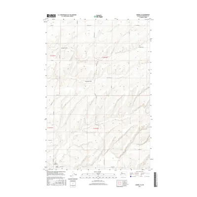
2017 Map of Connell SE
USGS Topo · Published 2017About this map
Old Maid Coulee and Dunnigan Coulee carve through this Franklin County landscape, reflecting the distinct geological drainage patterns of the Columbia Basin. The area is defined by a grid of agricultural and connector roads, with the small settlement of Five Corners situated at a crossroads in the southwestern corner near Smith Canyon. The U.S. Geological Survey and Department of the Interior recorded a network of thoroughfares including Fishook Elgin Rd, Mesa Kahlotus Rd, and Smith Rd, which serve the local farmsteads and rural properties. Many of these routes, such as Bauermeister Rd and Lindner Rd, carry the names of local families, providing a clear picture of land use and rural infrastructure in the early 21st century.
Find a feature on this map
24 named features on this map. Tap any name to fly to it.
Don’t see what you’re looking for? This feature index may not catch every label — zoom into the map to look around manually.
Map Details
Editions of this 2017 Connell SE Map
This is the sole edition of this map. No revisions or reprints were ever made.
Other maps of this area

1915 · Wallulah
USGS Topo · 1:96,000

1916 · Connell
USGS Topo · 1:125,000

1918 · Connell
USGS Topo · 1:125,000

1918 · Wallula
USGS Topo · 1:125,000

1953 · Walla Walla
USGS Topo · 1:250,000

1958 · Walla Walla
USGS Topo · 1:250,000

1963 · Rye Grass Coulee
USGS Topo · 1:24,000

1964 · Levey NE
USGS Topo · 1:24,000

1966 · Snake River
USGS Topo · 1:24,000
1970 · Burr Canyon
USGS Topo · 1:24,000