
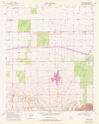
1955 Map of Conner SW
USGS Topo · Published 1956About this map
Agricultural and industrial operations define this mid-1950s landscape in Kern County, where the southern San Joaquin Valley meets the rising terrain of the Pleito Hills. The map captures a moment of intense resource management, characterized by a complex network of infrastructure including a Levee, multiple Pipelines, and a systematic grid of Wells. The presence of the Los Lobos Oil Field in the southwestern quadrant, alongside the Lakeview Labor Camp and a Cotton Gin to the north, illustrates the dual reliance on petroleum extraction and industrial-scale farming. Water management is central to the area's utility, marked by numerous Reservoirs and Water Tanks that support the dry lands between San Emigdio Creek and Los Lobos Creek. Transportation is anchored by the Maricopa Highway and Copus Road, providing essential transit for the region's labor and products.
Find a feature on this map
24 named features on this map. Tap any name to fly to it.
Don’t see what you’re looking for? This feature index may not catch every label — zoom into the map to look around manually.
Map Details
Editions of this 1955 Conner SW Map
4 editions found


Other maps of this area

1903 · Mt. Pinos
USGS Topo · 1:125,000

1910 · Buena Vista Lake
USGS Topo · 1:125,000

1912 · Buena Vista Lake
USGS Topo · 1:125,000

1929 · Mouth of Kern
USGS Topo · 1:31,680

1930 · Millux
USGS Topo · 1:31,680

1930 · Conner
USGS Topo · 1:31,680

1931 · Pentland Junction
USGS Topo · 1:31,680

1931 · Hayes Ranch
USGS Topo · 1:31,680

1932 · Mouth of Kern
USGS Topo · 1:31,680

1933 · Hayes Ranch
USGS Topo · 1:31,680