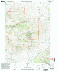
2001 Map of Connor Ridge
USGS Topo · Published 2006About this map
The California National Historic Trail cuts across the southern portion of this landscape, tracing the historical migration route through the Elba Basin. This corridor, shadowed by the steep Albion Mountains, illustrates the transition from rugged high-altitude terrain to the irrigated agricultural flats near Clyde and Connor. The northern half of the sheet is dominated by the Sawtooth National Forest, where steep drainages like Broad Hollow and Brim Canyon descend from the central Connor Ridge.
Find a feature on this map
34 named features on this map. Tap any name to fly to it.
Don’t see what you’re looking for? This feature index may not catch every label — zoom into the map to look around manually.
Map Details
Editions of this 2001 Connor Ridge Map
This is the sole edition of this map. No revisions or reprints were ever made.
Other maps of this area

1954 · Pocatello
USGS Topo · 1:250,000

1958 · Pocatello
USGS Topo · 1:250,000

1964 · View
USGS Topo · 1:24,000

1968 · Cache Peak
USGS Topo · 1:24,000

1968 · Idahome
USGS Topo · 1:24,000

1968 · Elba
USGS Topo · 1:24,000

1968 · Kane Canyon
USGS Topo · 1:24,000

1968 · Mount Harrison
USGS Topo · 1:24,000

1968 · Nibbs Creek
USGS Topo · 1:24,000

1968 · Albion
USGS Topo · 1:24,000