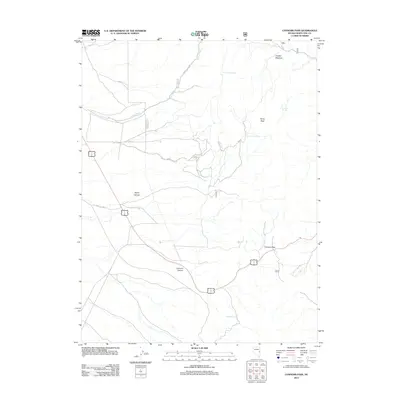
2012 Map of Connors Pass
USGS Topo · Published 2012About this map
Connors Pass serves as the primary gateway through the high terrain of White Pine County, where a single highway route winds between the elevations of Taylor Peak and the surrounding basin. The geography is defined by a network of seasonal water sources and drainages, including the lengthy Cooper Wash and scattered watering points such as Crethers Springs and Rosebud Spring. This high-desert landscape is marked by steep transitions between sheltered areas like Cooper Meadow and the deep cuts of Taylor Canyon and Connors Canyon. A few maintained county roads, such as White Pine Co Road 26, provide the only access into these remote reaches of the Great Basin, tracing the paths of natural drainages to reach the higher mountain passes.
Find a feature on this map
14 named features on this map. Tap any name to fly to it.
Don’t see what you’re looking for? This feature index may not catch every label — zoom into the map to look around manually.
Map Details
Editions of this 2012 Connors Pass Map
This is the sole edition of this map. No revisions or reprints were ever made.
Other maps of this area

1952 · Ely
USGS Topo · 1:125,000

1956 · Lund
USGS Topo · 1:250,000

1956 · Ely
USGS Topo · 1:250,000

1958 · Comins Lake
USGS Topo · 1:24,000

1958 · Ely
USGS Topo · 1:62,500

1959 · Ely
USGS Topo · 1:250,000

1959 · Connors Pass
USGS Topo · 1:62,500

1960 · Lund
USGS Topo · 1:250,000

1963 · Ely
USGS Topo · 1:250,000
1973 · White Rock Creek
USGS Topo · 1:24,000