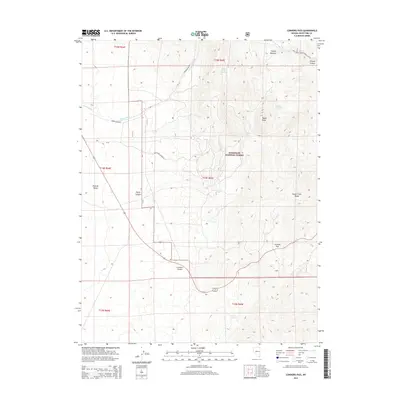
2014 Map of Connors Pass
USGS Topo · Published 2014About this map
The Schell Creek Range dominates this portion of White Pine County, forming a high-elevation spine that separates the Steptoe Valley to the west from the rugged interior of the Humboldt National Forest. This high desert terrain is defined by dramatic changes in relief, rising from the valley floor toward Taylor Peak and descending into steep drainages such as Connors Canyon and Taylor Canyon. The passage through Connors Pass provides a critical transit point across the range, a route utilized by regional travelers and local ranchers for decades.
Find a feature on this map
24 named features on this map. Tap any name to fly to it.
Don’t see what you’re looking for? This feature index may not catch every label — zoom into the map to look around manually.
Map Details
Editions of this 2014 Connors Pass Map
This is the sole edition of this map. No revisions or reprints were ever made.
Other maps of this area

1952 · Ely
USGS Topo · 1:125,000

1956 · Lund
USGS Topo · 1:250,000

1956 · Ely
USGS Topo · 1:250,000

1958 · Comins Lake
USGS Topo · 1:24,000

1958 · Ely
USGS Topo · 1:62,500

1959 · Ely
USGS Topo · 1:250,000

1959 · Connors Pass
USGS Topo · 1:62,500

1960 · Lund
USGS Topo · 1:250,000

1963 · Ely
USGS Topo · 1:250,000
1973 · White Rock Creek
USGS Topo · 1:24,000