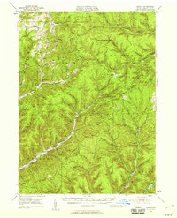
1947 Map of Conrad
USGS Topo · Published 1958About this map
The headwaters of Pine Creek and the East Fork Sinnemahoning Creek dominate this 1947 survey of Potter County, Pennsylvania. The map highlights a remote landscape characterized by steep valleys and family-named landmarks, reflecting a mid-century period when forestry and conservation efforts were well-established. Significant public land tracks like Summit and Stewardson show the scale of state forest management, while specific points of interest like Cherry Springs Park and Patterson Park mark early recreational development.
Find a feature on this map
57 named features on this map. Tap any name to fly to it.
Don’t see what you’re looking for? This feature index may not catch every label — zoom into the map to look around manually.
Map Details
Editions of this 1947 Conrad Map
4 editions found

Other maps of this area

1899 · Gaines
USGS Topo · 1:62,500

1900 · Gaines
USGS Topo · 1:62,500

1932 · Genesee
USGS Topo · 1:62,500

1934 · Coudersport
USGS Topo · 1:48,000

1937 · Genesee
USGS Topo · 1:62,500

1938 · Coudersport
USGS Topo · 1:62,500

1943 · Hyner
USGS Topo · 1:62,500

1945 · Driftwood
USGS Topo · 1:48,000

1945 · First Fork
USGS Topo · 1:24,000

1946 · Young Womans Creek
USGS Topo · 1:24,000
Featured Places
- Sweden Township, PA
- Abbott Township, PA
- Wharton Township, PA
- Borie, Summit Township
- West Branch Township, PA