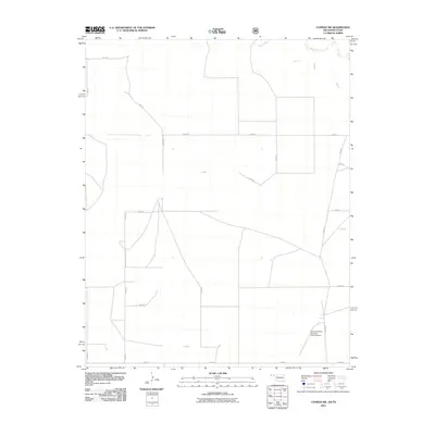
2011 Map of Conrad SW
USGS Topo · Published 2011About this map
Beaver River winds through the northern portion of this Cimarron County landscape, marking one of the few natural interruptions to a highly structured grid of section roads. This 2011 survey illustrates the rural character of the Oklahoma-Texas borderlands, where the landscape is defined by vast ranching tracts and an organized network of numbered routes such as E0350 Rd and N0310 Rd. A notable modern landmark in this corner of the High Plains is the Perkins-Prothro Cimarron Ranch Airport, situated in the southeastern section of the quadrangle. The map captures the intersection of traditional land use and the infrastructure required for large-scale agricultural and ranching operations at the start of the twenty-first century.
Find a feature on this map
20 named features on this map. Tap any name to fly to it.
Don’t see what you’re looking for? This feature index may not catch every label — zoom into the map to look around manually.
Map Details
Editions of this 2011 Conrad SW Map
This is the sole edition of this map. No revisions or reprints were ever made.
Other maps of this area

1954 · Dalhart
USGS Topo · 1:250,000

1958 · Dalhart
USGS Topo · 1:250,000

1962 · Dalhart
USGS Topo · 1:250,000

1964 · Stratford 2 NE
USGS Topo · 1:24,000

1969 · Boise City
USGS Topo · 1:24,000

1969 · Boise City SE
USGS Topo · 1:24,000

1971 · Sampsel Lake
USGS Topo · 1:24,000

1971 · Conrad NW
USGS Topo · 1:24,000

1971 · Conrad SW
USGS Topo · 1:24,000
1971 · Conrad
USGS Topo · 1:24,000