2023 Map of Constableville
USGS Topo · Published 2023About this map
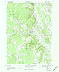
Constableville serves as the central hub of this Lewis County landscape, situated where the Sugar River begins its descent toward the Black River valley. The terrain is defined by the high elevations of Tug Hill to the west and Mohawk Hill to the south, creating a watershed that feeds numerous tributaries including the North Branch Sugar River and Olmstead Brook. The settlement pattern reflects the area's agricultural and milling roots, with clusters at Turin and Lyons Falls connected by a network of rural roads like Crofoot Hill Rd and State Truck Trl. Several historic burial grounds, such as Constableville Rural Cem and Saint Pauls Cem, are located on the rising slopes above the river, providing valuable location data for genealogists tracking early families in the region. The map captures the balance between the dense woodlands of the higher hills and the open valley floors around Locust Grove.
Find a feature on this map
75 named features on this map. Tap any name to fly to it.
Don’t see what you’re looking for? This feature index may not catch every label — zoom into the map to look around manually.
Map Details
Editions of this 2023 Constableville Map
This is the sole edition of this map. No revisions or reprints were ever made.