
1932 Map of Constance Bayou NE
USGS Topo · Published 1932About this map
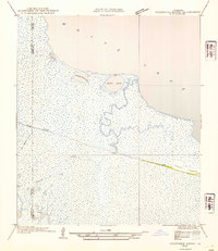
White Lake dominates the northern expanse of this 1932 coastal survey, revealing the intricate marshland geography of south Louisiana before significant modern modification. The landscape is defined by its transition from open water to the complex drainage of the Floating Turf Bayou, which meanders south from Bear Lake through a saturated environment. To the south, the elevated ridge of Pecan Island emerges from the marsh, providing a stark contrast to the surrounding lowlands.
Find a feature on this map
9 named features on this map. Tap any name to fly to it.
Don’t see what you’re looking for? This feature index may not catch every label — zoom into the map to look around manually.
Map Details
Editions of this 1932 Constance Bayou NE Map
2 editions found
Other maps of this area

1932 · Constance Bayou SW
USGS Topo · 1:31,680

1932 · Pecan Island SW
USGS Topo · 1:31,680

1932 · Constance Bayou SE
USGS Topo · 1:31,680

1932 · Constance Bayou NW
USGS Topo · 1:31,680

1945 · Pecan Island NW
USGS Topo · 1:31,680

1946 · Schooner Bayou SW
USGS Topo · 1:31,680

1951 · Pecan Island
USGS Topo · 1:62,500

1953 · Jacks Point Island
USGS Topo · 1:24,000

1954 · Grand Lake East SE
USGS Topo · 1:31,680
1954 · Grand Lake East SW
USGS Topo · 1:31,680