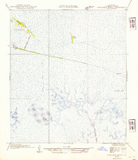
1954 Map of Constance Bayou NW
USGS Topo · Published 1954About this map
North Island and the surrounding marshlands of Cameron Parish define this coastal landscape as it was documented in the early 1930s. The area is characterized by an intricate network of waterways and isolated higher ground, such as Money Island and the enigmatic stretch labeled No Mans Land. At Tiger Island, small settlements like Miller and the North Island Sch indicate a remote community reliant on the marsh's geography. The presence of the North Island Canal cutting through the terrain suggests early 20th-century efforts to manage water or facilitate transport through these wetlands. Large open water bodies like Deep Lake and the winding course of Constance Bayou dominate the southern portion of the sheet, providing a clear record of the hydrologic patterns before modern coastal changes.
Find a feature on this map
13 named features on this map. Tap any name to fly to it.
Don’t see what you’re looking for? This feature index may not catch every label — zoom into the map to look around manually.
Map Details
Editions of this 1954 Constance Bayou NW Map
This is the sole edition of this map. No revisions or reprints were ever made.
Other maps of this area

1932 · Constance Bayou NE
USGS Topo · 1:31,680

1932 · Constance Bayou SW
USGS Topo · 1:31,680

1932 · Constance Bayou SE
USGS Topo · 1:31,680

1932 · Constance Bayou NW
USGS Topo · 1:31,680

1934 · Catfish Lake
USGS Topo · 1:24,000

1935 · Catfish Lake
USGS Topo · 1:31,680

1946 · Hog Bayou NE
USGS Topo · 1:31,680

1949 · Hog Bayou NE
USGS Topo · 1:31,680

1954 · Grand Lake East SE
USGS Topo · 1:31,680
1954 · Grand Lake East SW
USGS Topo · 1:31,680