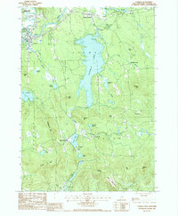
1987 Map of Conway
USGS Topo · Published 1987About this map
The Saco River and its confluence with the Swift River anchor the northern landscape of this Carroll County region, where the town of Conway serves as a primary hub. The terrain is defined by a dense network of glacial lakes and prominent peaks, with Conway Lake dominating the central portion of the sheet. To the south, the village of Eaton Center sits near Crystal Lake, while the smaller settlement of Snowville is tucked between Birch Hill and the waters of Snow Brook.
Find a feature on this map
44 named features on this map. Tap any name to fly to it.
Don’t see what you’re looking for? This feature index may not catch every label — zoom into the map to look around manually.
Map Details
Editions of this 1987 Conway Map
2 editions found
Other maps of this area

1894 · North Conway
USGS Topo · 1:62,500

1896 · North Conway
USGS Topo · 1:62,500

1909 · Fryeburg
USGS Topo · 1:62,500

1910 · Kezar Falls
USGS Topo · 1:48,000

1911 · Fryeburg
USGS Topo · 1:62,500

1911 · Kezar Falls
USGS Topo · 1:62,500

1930 · Ossipee Lake
USGS Topo · 1:62,500

1941 · Fryeburg
USGS Topo · 1:62,500

1942 · North Conway
USGS Topo · 1:62,500

1945 · North Conway
USGS Topo · 1:62,500