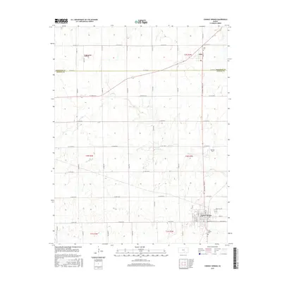
2015 Map of Conway Springs
USGS Topo · Published 2015About this map
Conway Springs serves as the primary population center in the southeastern corner of this 2015 survey, situated just south of the boundary where Sedgwick Co and Sumner Co meet. The township-and-range grid is heavily defined by agricultural section lines and a network of arterial roads like N Conway Springs Rd and N Bluff Rd. This landscape reflects the rural continuity of the region, where small settlements such as Anness and Viola are anchored by local landmarks like the Viola Cem and Saint Josephs Cem. Drainage patterns are dictated by the meandering paths of Slate Cr and its tributaries, including S Br Slate Cr and N Br State Cr, which break the otherwise rigid geometry of the wheat-growing plains. Local aviation history is also noted with the presence of Wamsley Field east of the main town.
Find a feature on this map
52 named features on this map. Tap any name to fly to it.
Don’t see what you’re looking for? This feature index may not catch every label — zoom into the map to look around manually.
Map Details
Editions of this 2015 Conway Springs Map
This is the sole edition of this map. No revisions or reprints were ever made.
Other maps of this area

1889 · Cheney
USGS Topo · 1:125,000

1889 · Caldwell
USGS Topo · 1:125,000

1891 · Cheney
USGS Topo · 1:125,000

1893 · Caldwell
USGS Topo · 1:125,000

1897 · Caldwell
USGS Topo · 1:125,000

1901 · Cheney
USGS Topo · 1:125,000

1955 · Wichita
USGS Topo · 1:250,000

1958 · Wichita
USGS Topo · 1:250,000

1965 · Cheney SE
USGS Topo · 1:24,000
1965 · Clearwater
USGS Topo · 1:24,000