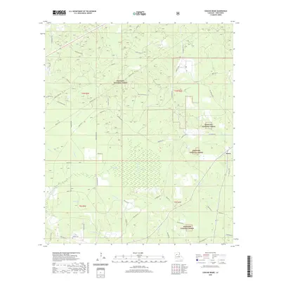
2020 Map of Coochie Brake
USGS Topo · Published 2020About this map
Kisatchie National Forest dominates the landscape of southern Winn Parish, where the complex wetlands of Coochie Brake form a significant natural basin. This 2020 edition detail reveals a rural network of parish roads and forest routes that connect isolated landmarks such as the Kimbrell Cem and the settlement of Atlanta at the eastern edge. The map captures the intricate drainage patterns of the region, defined by the winding courses of Nantachie Cr, Iatt Cr, and Couley Cr. Unlike earlier surveys, this modern topographic representation highlights the extensive interface between public forest lands and private holdings, crisscrossed by roads like Double Church Rd and Bethleham Rd. The terrain is characterized by subtle elevation changes that guide various branches and creeks, including Dortigo Cr and Joe-Mitchell Br, through the heavily timbered environment.
Find a feature on this map
55 named features on this map. Tap any name to fly to it.
Don’t see what you’re looking for? This feature index may not catch every label — zoom into the map to look around manually.
Map Details
Editions of this 2020 Coochie Brake Map
This is the sole edition of this map. No revisions or reprints were ever made.
Other maps of this area

1932 · Colfax NW
USGS Topo · 1:31,680

1935 · Verda
USGS Topo · 1:31,680

1936 · Colfax
USGS Topo · 1:62,500

1937 · Montgomery
USGS Topo · 1:62,500

1942 · Montgomery
USGS Topo · 1:62,500

1945 · Montgomery
USGS Topo · 1:62,500

1949 · Calvin SE
USGS Topo · 1:31,680

1949 · Calvin NE
USGS Topo · 1:31,680

1949 · Calvin NW
USGS Topo · 1:31,680

1949 · Calvin SW
USGS Topo · 1:31,680