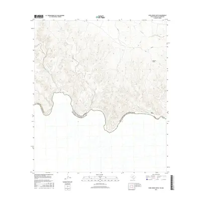
2016 Map of Cook Creek South
USGS Topo · Published 2016About this map
The Rio Grande Wild and Scenic River forms a jagged international boundary through this portion of Terrell County, carving a deep path between Texas and the United States of America and Mexico. The landscape is dominated by a complex network of dry washes and drainage systems that feed into the river, including the winding Cook Creek and Indian Cr. High elevation points are dissected by dramatic terrain features like Mesquite Canyon and Bear Canyon, which highlight the stark relief of the Chihuahuan Desert. While largely devoid of major settlements, the map illustrates the remote infrastructure of the Texas borderlands, where established trails and tracks like Cedar Rd navigate the high plateaus above Lozier Creek. This survey captures the topographical isolation of the southern Terrell County corridor.
Find a feature on this map
12 named features on this map. Tap any name to fly to it.
Don’t see what you’re looking for? This feature index may not catch every label — zoom into the map to look around manually.
Map Details
Editions of this 2016 Cook Creek South Map
This is the sole edition of this map. No revisions or reprints were ever made.
Other maps of this area

1918 · Dryden Crossing
USGS Topo · 1:62,500

1943 · Malvado
USGS Topo · 1:62,500

1944 · Malvado
USGS Topo · 1:62,500

1958 · Del Rio
USGS Topo · 1:250,000

1959 · Emory Peak
USGS Topo · 1:250,000

1964 · Del Rio
USGS Topo · 1:250,000

1965 · Emory Peak
USGS Topo · 1:250,000
1979 · Cook Creek North
USGS Topo · 1:24,000
1979 · Lozier Canyon North
USGS Topo · 1:24,000
1979 · Cook Creek South
USGS Topo · 1:24,000