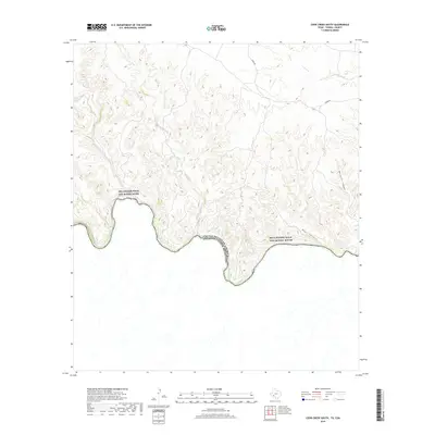
2019 Map of Cook Creek South
USGS Topo · Published 2019About this map
The Rio Grande Wild and Scenic River forms the southern boundary of this West Texas landscape, marking the international border between the United States of America and Mexico. The terrain north of the Rio Grande is defined by a dense network of drainage systems, where Cook Creek and Cow Creek carve through the high ground. This 2019 survey shows a largely undeveloped region within Terrell County, characterized by steep elevation changes and prominent natural landmarks like Mesquite Canyon and Bear Canyon. Human infrastructure is sparse, limited primarily to Cedar Rd as it traverses the northern elevations. This map serves as a contemporary record of the protected river corridor and the complex topography of the Trans-Pecos, providing detail for researchers tracking land use and natural watercourses like Indian Creek in this remote borderland.
Find a feature on this map
12 named features on this map. Tap any name to fly to it.
Don’t see what you’re looking for? This feature index may not catch every label — zoom into the map to look around manually.
Map Details
Editions of this 2019 Cook Creek South Map
This is the sole edition of this map. No revisions or reprints were ever made.
Other maps of this area

1918 · Dryden Crossing
USGS Topo · 1:62,500

1943 · Malvado
USGS Topo · 1:62,500

1944 · Malvado
USGS Topo · 1:62,500

1958 · Del Rio
USGS Topo · 1:250,000

1959 · Emory Peak
USGS Topo · 1:250,000

1964 · Del Rio
USGS Topo · 1:250,000

1965 · Emory Peak
USGS Topo · 1:250,000
1979 · Cook Creek North
USGS Topo · 1:24,000
1979 · Lozier Canyon North
USGS Topo · 1:24,000
1979 · Cook Creek South
USGS Topo · 1:24,000