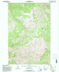
1994 Map of Cook Mountain
USGS Topo · Published 1997About this map
Cook Mountain stands as the central landmark of this high-elevation landscape within the Clearwater National Forest, where the terrain is defined by a dense network of watercourses and prominent ridgelines. The map details the administrative division between the North Fork Pierce Ranger District and surrounding forest lands, spanning the boundary of Clearwater and Idaho Counties. Historically significant for forest management and back-country access, the area features Magary Camp and various meadows that break the forest cover, such as Crater Meadows. Drainage patterns are clearly marked by the westward flow of Davis Creek and the southern reach of Weitas Creek, which dominates the lower portion of the sheet. Other notable landforms like Buck Ridge, Fox Butte, and Smith Butte provide the primary orientation points for this remote section of the Clearwater region.
Find a feature on this map
25 named features on this map. Tap any name to fly to it.
Don’t see what you’re looking for? This feature index may not catch every label — zoom into the map to look around manually.
Map Details
Editions of this 1994 Cook Mountain Map
This is the sole edition of this map. No revisions or reprints were ever made.
Other maps of this area

1911 · Lolo
USGS Topo · 1:250,000

1913 · Lolo
USGS Topo · 1:250,000

1956 · Hamilton
USGS Topo · 1:250,000

1959 · Hamilton
USGS Topo · 1:250,000

1960 · Hamilton
USGS Topo · 1:250,000

1964 · Hamilton
USGS Topo · 1:250,000

1965 · Junction Mtn
USGS Topo · 1:24,000

1965 · Lean-to Point
USGS Topo · 1:24,000

1965 · Scurvy Mtn.
USGS Topo · 1:24,000

1965 · Lookout Peak
USGS Topo · 1:24,000