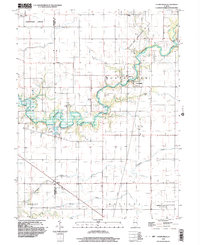
1998 Map of Cooks Mills
USGS Topo · Published 2003About this map
The Kaskaskia River snakes across the heart of this landscape, its winding course defining the transition between the townships of North Okaw and East Nelson. At the turn of the millennium, the area reflects a deeply rooted rural infrastructure where the small settlement of Cooks Mills and the nearby Cooks Mills Consolidated Oil Field highlight the dual reliance on agriculture and subterranean resources. The presence of numerous active oil wells and the North Mattoon Oil Field in the south underscores the industrial character of this corner of Illinois.
Find a feature on this map
27 named features on this map. Tap any name to fly to it.
Don’t see what you’re looking for? This feature index may not catch every label — zoom into the map to look around manually.
Map Details
Editions of this 1998 Cooks Mills Map
This is the sole edition of this map. No revisions or reprints were ever made.
Other maps of this area

1934 · Mattoon
USGS Topo · 1:62,500

1935 · Arcola
USGS Topo · 1:48,000

1935 · Sullivan
USGS Topo · 1:48,000

1937 · Mattoon
USGS Topo · 1:62,500

1940 · Sullivan
USGS Topo · 1:62,500

1940 · Arcola
USGS Topo · 1:62,500

1947 · Stewardson
USGS Topo · 1:62,500

1949 · Stewardson
USGS Topo · 1:62,500

1958 · Decatur
USGS Topo · 1:250,000

1961 · Decatur
USGS Topo · 1:250,000