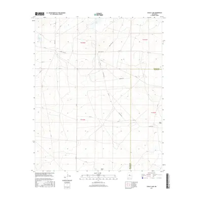
2017 Map of Cooley Lake
USGS Topo · Published 2017About this map
Deering Place and the Howell Ranch anchor this high plains landscape along the border of Chaves and De Baca counties. The terrain is defined by a series of isolated water features and significant relief, including Cooley Lake in the northwest and Salt Lake at the southern edge. The area's ranching legacy is reflected in the extensive grid of rural roads, such as Liberty School Rd and Enchantment Rd, which connect scattered homesteads and livestock tanks. Dominant topographical landmarks like La Espia Peak, Eighteenmile Hill, and Watts Hill provide navigational cues across the arid landscape. The presence of White Draw and Urton Lake further illustrates the complex drainage patterns and seasonal water sources that have historically supported grazing and local settlement in this part of New Mexico.
Find a feature on this map
36 named features on this map. Tap any name to fly to it.
Don’t see what you’re looking for? This feature index may not catch every label — zoom into the map to look around manually.
Map Details
Editions of this 2017 Cooley Lake Map
This is the sole edition of this map. No revisions or reprints were ever made.
Other maps of this area

1954 · Fort Sumner
USGS Topo · 1:250,000

1955 · Roswell
USGS Topo · 1:250,000

1958 · Fort Sumner
USGS Topo · 1:250,000

1958 · Roswell
USGS Topo · 1:250,000

1962 · Roswell
USGS Topo · 1:250,000

1967 · Deering Place
USGS Topo · 1:24,000

1967 · Eighteenmile Hill
USGS Topo · 1:24,000

1967 · Hernandez Lake
USGS Topo · 1:24,000
1967 · La Espia Peak
USGS Topo · 1:24,000
1967 · Conejo Creek East
USGS Topo · 1:24,000