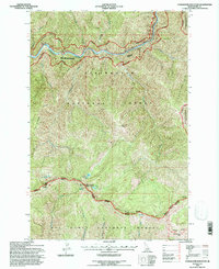
1994 Map of Coolwater Mountain
USGS Topo · Published 1997About this map
The Lochsa River carves a deep path through the northern reaches of this Idaho landscape, which was updated in the mid-1990s following extensive aerial photography. This region is a confluence of major protected lands, where the Clearwater National Forest meets the Nez Perce National Forest along the prominent Coolwater Ridge. High-altitude features like Coolwater Mountain and Andys Hump overlook a network of alpine waters, including Coolwater Lake and Andys Lakes. The map documents the boundary of the Selway-Bitterroot Wilderness on its eastern edge, alongside recreational corridors and the Roundtop NRT trail. Notable for backcountry researchers are the isolated locations of Indian Spring and Remount Spring, which served as vital water sources in this steep terrain of the Selway-Lochsa Ranger District.
Find a feature on this map
28 named features on this map. Tap any name to fly to it.
Don’t see what you’re looking for? This feature index may not catch every label — zoom into the map to look around manually.
Map Details
Editions of this 1994 Coolwater Mountain Map
This is the sole edition of this map. No revisions or reprints were ever made.
Other maps of this area

1911 · Lolo
USGS Topo · 1:250,000

1913 · Lolo
USGS Topo · 1:250,000

1924 · Weippe
USGS Topo · 1:125,000

1956 · Hamilton
USGS Topo · 1:250,000

1959 · Hamilton
USGS Topo · 1:250,000

1960 · Hamilton
USGS Topo · 1:250,000

1964 · Hamilton
USGS Topo · 1:250,000

1966 · Selway Falls
USGS Topo · 1:24,000

1966 · Lowell
USGS Topo · 1:24,000
1966 · Stillman Point
USGS Topo · 1:24,000