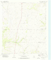
1973 Map of Coon Dive Draw
USGS Topo · Published 1976About this map
Deep drainage patterns define the landscape of this West Texas territory, where the complex systems of Coon Dive Draw and North Liveoak Draw cut through the rugged rangeland. During the early 1970s, this area remained largely dominated by sprawling pastoral holdings, including the McGill Ranch, Barrett Ranch, and Peibandt Ranch. The map captures the infrastructure of the modern ranching era, characterized by isolated water sources like the Coon Dive Windmill and industrial markers such as the Pumping Sta and a prominent Pipeline cutting across the county lines. The convergence of three counties — Sterling, Tom Green, and Irion — occurs amidst this remote terrain, where a lonely Landing Strip and several gravel pits represent the only significant deviations from the natural topography.
Find a feature on this map
18 named features on this map. Tap any name to fly to it.
Don’t see what you’re looking for? This feature index may not catch every label — zoom into the map to look around manually.
Map Details
Editions of this 1973 Coon Dive Draw Map
This is the sole edition of this map. No revisions or reprints were ever made.
Other maps of this area

1895 · Sherwood
USGS Topo · 1:125,000

1921 · Ketchum Mountain
USGS Topo · 1:62,500

1923 · Ketchum Mountain
USGS Topo · 1:62,500

1954 · San Angelo
USGS Topo · 1:250,000

1958 · San Angelo
USGS Topo · 1:250,000

1965 · San Angelo
USGS Topo · 1:250,000

1972 · Wallace Draw
USGS Topo · 1:24,000

1972 · Dog Creek SW
USGS Topo · 1:24,000

1972 · Dog Creek NW
USGS Topo · 1:24,000

1973 · Hay Hollow
USGS Topo · 1:24,000