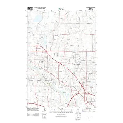
2013 Map of Coon Rapids
USGS Topo · Published 2013About this map
The Mississippi River creates a natural boundary between Anoka Co and Hennepin Co, defining the character of this suburban landscape. Along the eastern banks, the developed neighborhoods of Thompson Riverview Terrace and West Coon Rapids sit adjacent to the educational hub of Anoka-Ramsey Community Coll. The terrain is characterized by a mix of residential expansion and preserved recreational space, including the expansive Bunker Hills Golf Course and the Bunker Prairie Lookout Tower. For those tracing local heritage, several burial grounds are documented, including Epiphany Catholic Church Cem, Joyce Chapel Cem, and Morningside Memorial Gardens Cem. The map detail follows the path of Coon Cr and Sand Cr as they move toward the river, passing through the established communities of Northdale and Oak Park.
Find a feature on this map
112 named features on this map. Tap any name to fly to it.
Don’t see what you’re looking for? This feature index may not catch every label — zoom into the map to look around manually.
Map Details
Editions of this 2013 Coon Rapids Map
This is the sole edition of this map. No revisions or reprints were ever made.
Other maps of this area

1902 · White Bear
USGS Topo · 1:62,500

1902 · Anoka
USGS Topo · 1:62,500

1916 · St. Francis
USGS Topo · 1:62,500

1919 · St. Francis
USGS Topo · 1:62,500

1952 · Minneapolis North
USGS Topo · 1:24,000

1952 · New Brighton
USGS Topo · 1:24,000

1953 · Stillwater
USGS Topo · 1:250,000

1955 · Osseo
USGS Topo · 1:24,000

1955 · Circle Pines
USGS Topo · 1:24,000

1955 · Anoka
USGS Topo · 1:24,000