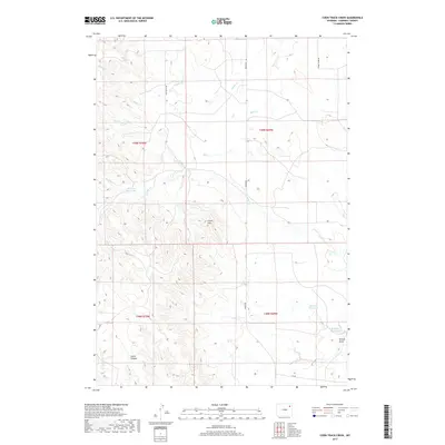
2017 Map of Coon Track Creek
USGS Topo · Published 2017About this map
Chalk Hills rises as a central topographic feature in this section of Campbell County, where the high plains are carved by a complex network of seasonal drainages and small ranching impoundments. The landscape is defined by the convergence of several waterways including Coon Track Creek, Timber Creek, and the multiple branches of Buck Creek. This 2017 survey illustrates the continued importance of water management in this arid Wyoming environment, documented through named features like Raccoon Reservoir, Brower Reservoir, and Williams Reservoir.
Find a feature on this map
21 named features on this map. Tap any name to fly to it.
Don’t see what you’re looking for? This feature index may not catch every label — zoom into the map to look around manually.
Map Details
Editions of this 2017 Coon Track Creek Map
This is the sole edition of this map. No revisions or reprints were ever made.
Other maps of this area

1954 · Gillette
USGS Topo · 1:250,000

1955 · Gillette
USGS Topo · 1:250,000

1958 · Gillette
USGS Topo · 1:250,000

1962 · Gillette
USGS Topo · 1:250,000

1971 · Coyote Draw
USGS Topo · 1:24,000

1971 · Coon Track Creek
USGS Topo · 1:24,000

1971 · Whitetail Creek
USGS Topo · 1:24,000
1971 · Whitetail Creek SE
USGS Topo · 1:24,000

1971 · Rozet
USGS Topo · 1:24,000
1971 · Rozet SE
USGS Topo · 1:24,000