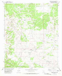
1981 Map of Cooper Canyon
USGS Topo · Published 1982About this map
Chupadera Mesa dominates the landscape of this Socorro County region, where the high desert terrain is defined by a network of drainage systems like Yellow Dog Canyon and Cooper Canyon. During the early 1980s, this area supported livestock and resource extraction, evidenced by the numerous water improvements and the presence of the Naulda Mine along Iron Mountain Ridge. The distribution of features such as School Section Windmill and School Section Tank suggests the utilization of public land for ranching, while isolated landmarks like Malina Windmill and New Forest Windmill provide specific points of reference for those tracing historical land use. To the south, Hoot Owl Canyon and Lobo Canyon cut through the rugged slopes, illustrating the complex topography that governed movement through this arid territory.
Find a feature on this map
25 named features on this map. Tap any name to fly to it.
Don’t see what you’re looking for? This feature index may not catch every label — zoom into the map to look around manually.
Map Details
Editions of this 1981 Cooper Canyon Map
This is the sole edition of this map. No revisions or reprints were ever made.
Other maps of this area

1918 · Oscura Peak
USGS Topo · 1:125,000

1948 · Broken Back Crater
USGS Topo · 1:62,500

1948 · Bingham
USGS Topo · 1:62,500

1954 · Tularosa
USGS Topo · 1:250,000

1954 · Socorro
USGS Topo · 1:250,000

1958 · Socorro
USGS Topo · 1:250,000

1958 · Tularosa
USGS Topo · 1:250,000

1962 · Socorro
USGS Topo · 1:250,000

1972 · Turkey Ridge SW
USGS Topo · 1:24,000

1972 · Wilson Ranch
USGS Topo · 1:24,000