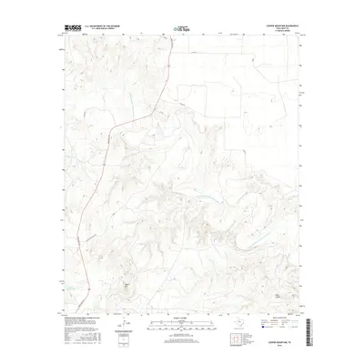
2016 Map of Cooper Mountain
USGS Topo · Published 2016About this map
Double Mountain Fork Brazos River winds through the heart of this Kent County landscape, creating a complex network of eroded drainages and high plateaus. The terrain is defined by prominent elevations such as Cooper Mountain and the deep relief of Eagle Canyon to the southeast. Water management on the ranch lands is evident through features like Cogdell Ranch Lake, while the seasonal flow of Sand Creek and Cooper Creek further dissects the plains. Transportation in this part of West Texas is facilitated by Ranch Rd 1231, which serves as a primary north-south artery connecting the high ground to the surrounding valley floor. Remote ranching infrastructure is linked by local routes such as Harrington Ranch RD, highlighting the region's dedicated land use for large-scale cattle operations.
Find a feature on this map
11 named features on this map. Tap any name to fly to it.
Don’t see what you’re looking for? This feature index may not catch every label — zoom into the map to look around manually.
Map Details
Editions of this 2016 Cooper Mountain Map
This is the sole edition of this map. No revisions or reprints were ever made.
Other maps of this area

1932 · Camp Springs
USGS Topo · 1:62,500

1954 · Lubbock
USGS Topo · 1:250,000

1954 · Big Spring
USGS Topo · 1:250,000

1958 · Big Spring
USGS Topo · 1:250,000

1969 · Maverick Creek
USGS Topo · 1:24,000
1969 · Hudd
USGS Topo · 1:24,000

1969 · Cooper Mountain
USGS Topo · 1:24,000

1969 · Clairemont East
USGS Topo · 1:24,000

1969 · Clairemont West
USGS Topo · 1:24,000

1969 · T-O Creek
USGS Topo · 1:24,000