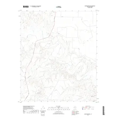
2019 Map of Cooper Mountain
USGS Topo · Published 2019About this map
The Double Mountain Fork Brazos River carves a complex drainage network across this portion of Kent County, creating a deeply eroded landscape defined by sharp elevation changes. The prominence of Cooper Mtn stands as a significant landmark in the southwestern quadrant, while the intricate topography of Eagle Canyon dominates the southeast. This 2019 survey reveals a rural Texas environment where infrastructure is primarily dictated by ranching and local transit. Ranch Rd 1231 serves as the principal artery, intersecting with several local routes including Harrington Ranch Rd. The map documents numerous unnamed structures and stock ponds scattered among the seasonal flows of Cooper Cr and Sand Cr, reflecting the region's long-standing reliance on traditional land use and water management in the Rolling Plains.
Find a feature on this map
11 named features on this map. Tap any name to fly to it.
Don’t see what you’re looking for? This feature index may not catch every label — zoom into the map to look around manually.
Map Details
Editions of this 2019 Cooper Mountain Map
This is the sole edition of this map. No revisions or reprints were ever made.
Other maps of this area

1932 · Camp Springs
USGS Topo · 1:62,500

1954 · Lubbock
USGS Topo · 1:250,000

1954 · Big Spring
USGS Topo · 1:250,000

1958 · Big Spring
USGS Topo · 1:250,000

1969 · Maverick Creek
USGS Topo · 1:24,000
1969 · Hudd
USGS Topo · 1:24,000

1969 · Cooper Mountain
USGS Topo · 1:24,000

1969 · Clairemont East
USGS Topo · 1:24,000

1969 · Clairemont West
USGS Topo · 1:24,000

1969 · T-O Creek
USGS Topo · 1:24,000