
1990 Map of Cooper Peak
USGS Topo · Published 1990About this map
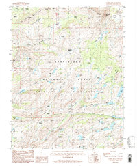
Cooper Peak rises as a prominent landmark in this high-elevation landscape within the Stanislaus National Forest. The terrain is defined by a series of alpine meadows and glacial basins, including Castle Meadow, Horse and Cow Meadow, and Studhorse Meadow, reflecting a long history of seasonal grazing and water management. The presence of Y Meadow Dam suggests the systematic control of high-country water resources to serve lower elevations, while the Emigrant Wilderness boundary preserves the primitive character of the surrounding peaks and canyons.
Find a feature on this map
60 named features on this map. Tap any name to fly to it.
Don’t see what you’re looking for? This feature index may not catch every label — zoom into the map to look around manually.
Map Details
Editions of this 1990 Cooper Peak Map
2 editions found
Historical Maps of Tuolumne County Through Time
228 maps found

1891 Big Trees
Tuolumne County, CA

1894 Big Trees
Tuolumne County, CA

1896 Dardanelles
Tuolumne County, CA

1897 Big Trees
Tuolumne County, CA

1898 Dardanelles
Tuolumne County, CA

1901 Big Trees
Tuolumne County, CA

1947 Jawbone Ridge
Tuolumne County, CA

1948 Columbia SE
Tuolumne County, CA

1948 Duckwall Mtn
Tuolumne County, CA

1948 Moccasin
Tuolumne County, CA

1948 Standard
Tuolumne County, CA

1948 Stanislaus
Tuolumne County, CA

1948 Tuolumne
Tuolumne County, CA

1948 Tuolumne
Tuolumne County, CA

1949 Columbia SE
Tuolumne County, CA

1949 Duckwall Mtn
Tuolumne County, CA

1949 Jawbone Ridge
Tuolumne County, CA

1949 Moccasin
Tuolumne County, CA

1949 Standard
Tuolumne County, CA

1949 Stanislaus
Tuolumne County, CA

1949 Tuolumne
Tuolumne County, CA

1956 Big Meadow
Tuolumne County, CA

1956 Dardanelles Cone
Tuolumne County, CA

1956 Hetch Hetchy Reservoir
Tuolumne County, CA

1956 Lake Eleanor
Tuolumne County, CA

1956 Pinecrest
Tuolumne County, CA

1956 Tower Peak
Tuolumne County, CA

1956 Tuolumne Meadows
Tuolumne County, CA

1962 Keystone
Tuolumne County, CA

1979 Boards Crossing
Tuolumne County, CA

1979 Cherry Lake North
Tuolumne County, CA

1979 Crandall Peak
Tuolumne County, CA

1979 Dardanelle
Tuolumne County, CA

1979 Donnell Lake
Tuolumne County, CA

1979 Hull Creek
Tuolumne County, CA

1979 Liberty Hill
Tuolumne County, CA

1979 Pinecrest
Tuolumne County, CA

1979 Sonora Pass
Tuolumne County, CA

1979 Strawberry
Tuolumne County, CA

1990 Ackerson Mountain
Tuolumne County, CA

1990 Ascension Mountain
Tuolumne County, CA

1990 Cherry Lake South
Tuolumne County, CA
1990 Cooper Peak
Tuolumne County, CA

1990 Emigrant Lake
Tuolumne County, CA

1990 Falls Ridge
Tuolumne County, CA

1990 Hetch Hetchy Reservoir
Tuolumne County, CA

1990 Kibbie Lake
Tuolumne County, CA

1990 Lake Eleanor
Tuolumne County, CA

1990 Matterhorn Peak
Tuolumne County, CA

1990 Piute Mountain
Tuolumne County, CA

1990 Tamarack Flat
Tuolumne County, CA

1990 Ten Lakes
Tuolumne County, CA

1990 Tiltill Mountain
Tuolumne County, CA

1990 Tioga Pass
Tuolumne County, CA

1990 Vogelsang Peak
Tuolumne County, CA

1992 Ackerson Mountain
Tuolumne County, CA

1992 Ascension Mountain
Tuolumne County, CA

1992 Cherry Lake South
Tuolumne County, CA

1992 Falls Ridge
Tuolumne County, CA

1992 Hetch Hetchy Reservoir
Tuolumne County, CA

1992 Lake Eleanor
Tuolumne County, CA

1992 Tamarack Flat
Tuolumne County, CA

1992 Ten Lakes
Tuolumne County, CA

1992 Tioga Pass
Tuolumne County, CA

1994 Tioga Pass
Tuolumne County, CA

1994 Vogelsang Peak
Tuolumne County, CA

1997 Tamarack Flat
Tuolumne County, CA

2000 Keystone
Tuolumne County, CA

2001 Ackerson Mountain
Tuolumne County, CA

2001 Ascension Mountain
Tuolumne County, CA

2001 Boards Crossing
Tuolumne County, CA

2001 Cherry Lake North
Tuolumne County, CA

2001 Cherry Lake South
Tuolumne County, CA

2001 Columbia SE
Tuolumne County, CA

2001 Cooper Peak
Tuolumne County, CA

2001 Crandall Peak
Tuolumne County, CA

2001 Dardanelle
Tuolumne County, CA

2001 Donnell Lake
Tuolumne County, CA

2001 Duckwall Mountain
Tuolumne County, CA

2001 Emigrant Lake
Tuolumne County, CA

2001 Hull Creek
Tuolumne County, CA

2001 Jawbone Ridge
Tuolumne County, CA

2001 Kibbie Lake
Tuolumne County, CA

2001 Lake Eleanor
Tuolumne County, CA

2001 Liberty Hill
Tuolumne County, CA

2001 Pinecrest
Tuolumne County, CA

2001 Sonora Pass
Tuolumne County, CA

2001 Stanislaus
Tuolumne County, CA

2001 Strawberry
Tuolumne County, CA

2001 Tiltill Mountain
Tuolumne County, CA

2001 Tuolumne
Tuolumne County, CA

2012 Ackerson Mountain
Tuolumne County, CA

2012 Ascension Mountain
Tuolumne County, CA

2012 Boards Crossing
Tuolumne County, CA

2012 Cherry Lake North
Tuolumne County, CA

2012 Cherry Lake South
Tuolumne County, CA

2012 Columbia SE
Tuolumne County, CA

2012 Cooper Peak
Tuolumne County, CA

2012 Crandall Peak
Tuolumne County, CA

2012 Dardanelle
Tuolumne County, CA

2012 Donnell Lake
Tuolumne County, CA

2012 Duckwall Mountain
Tuolumne County, CA

2012 Emigrant Lake
Tuolumne County, CA

2012 Falls Ridge
Tuolumne County, CA

2012 Hetch Hetchy Reservoir
Tuolumne County, CA

2012 Hull Creek
Tuolumne County, CA

2012 Jawbone Ridge
Tuolumne County, CA

2012 Keystone
Tuolumne County, CA

2012 Kibbie Lake
Tuolumne County, CA

2012 Lake Eleanor
Tuolumne County, CA

2012 Liberty Hill
Tuolumne County, CA

2012 Matterhorn Peak
Tuolumne County, CA

2012 Moccasin
Tuolumne County, CA

2012 Pinecrest
Tuolumne County, CA

2012 Piute Mountain
Tuolumne County, CA

2012 Sonora Pass
Tuolumne County, CA

2012 Standard
Tuolumne County, CA

2012 Stanislaus
Tuolumne County, CA

2012 Strawberry
Tuolumne County, CA

2012 Tamarack Flat
Tuolumne County, CA

2012 Ten Lakes
Tuolumne County, CA

2012 Tiltill Mountain
Tuolumne County, CA

2012 Tioga Pass
Tuolumne County, CA

2012 Tuolumne
Tuolumne County, CA

2012 Vogelsang Peak
Tuolumne County, CA

2015 Ackerson Mountain
Tuolumne County, CA

2015 Ascension Mountain
Tuolumne County, CA

2015 Boards Crossing
Tuolumne County, CA

2015 Cherry Lake North
Tuolumne County, CA

2015 Cherry Lake South
Tuolumne County, CA

2015 Columbia SE
Tuolumne County, CA

2015 Cooper Peak
Tuolumne County, CA

2015 Crandall Peak
Tuolumne County, CA

2015 Dardanelle
Tuolumne County, CA

2015 Donnell Lake
Tuolumne County, CA

2015 Duckwall Mountain
Tuolumne County, CA

2015 Emigrant Lake
Tuolumne County, CA

2015 Falls Ridge
Tuolumne County, CA

2015 Hetch Hetchy Reservoir
Tuolumne County, CA

2015 Hull Creek
Tuolumne County, CA

2015 Jawbone Ridge
Tuolumne County, CA

2015 Keystone
Tuolumne County, CA

2015 Kibbie Lake
Tuolumne County, CA

2015 Lake Eleanor
Tuolumne County, CA

2015 Liberty Hill
Tuolumne County, CA

2015 Matterhorn Peak
Tuolumne County, CA

2015 Moccasin
Tuolumne County, CA

2015 Pinecrest
Tuolumne County, CA

2015 Piute Mountain
Tuolumne County, CA

2015 Sonora Pass
Tuolumne County, CA

2015 Standard
Tuolumne County, CA

2015 Stanislaus
Tuolumne County, CA

2015 Strawberry
Tuolumne County, CA

2015 Tamarack Flat
Tuolumne County, CA

2015 Ten Lakes
Tuolumne County, CA

2015 Tiltill Mountain
Tuolumne County, CA

2015 Tioga Pass
Tuolumne County, CA

2015 Tuolumne
Tuolumne County, CA

2015 Vogelsang Peak
Tuolumne County, CA

2018 Ackerson Mountain
Tuolumne County, CA

2018 Ascension Mountain
Tuolumne County, CA

2018 Boards Crossing
Tuolumne County, CA

2018 Cherry Lake North
Tuolumne County, CA

2018 Cherry Lake South
Tuolumne County, CA

2018 Columbia SE
Tuolumne County, CA

2018 Cooper Peak
Tuolumne County, CA

2018 Crandall Peak
Tuolumne County, CA

2018 Dardanelle
Tuolumne County, CA

2018 Donnell Lake
Tuolumne County, CA

2018 Duckwall Mountain
Tuolumne County, CA

2018 Emigrant Lake
Tuolumne County, CA

2018 Falls Ridge
Tuolumne County, CA

2018 Hetch Hetchy Reservoir
Tuolumne County, CA

2018 Hull Creek
Tuolumne County, CA

2018 Jawbone Ridge
Tuolumne County, CA

2018 Keystone
Tuolumne County, CA

2018 Kibbie Lake
Tuolumne County, CA

2018 Lake Eleanor
Tuolumne County, CA

2018 Liberty Hill
Tuolumne County, CA

2018 Matterhorn Peak
Tuolumne County, CA

2018 Moccasin
Tuolumne County, CA

2018 Pinecrest
Tuolumne County, CA

2018 Piute Mountain
Tuolumne County, CA

2018 Sonora Pass
Tuolumne County, CA

2018 Standard
Tuolumne County, CA

2018 Stanislaus
Tuolumne County, CA

2018 Strawberry
Tuolumne County, CA

2018 Tamarack Flat
Tuolumne County, CA

2018 Ten Lakes
Tuolumne County, CA

2018 Tiltill Mountain
Tuolumne County, CA

2018 Tioga Pass
Tuolumne County, CA

2018 Tuolumne
Tuolumne County, CA

2018 Vogelsang Peak
Tuolumne County, CA

2021 Ackerson Mountain
Tuolumne County, CA

2021 Ascension Mountain
Tuolumne County, CA

2021 Boards Crossing
Tuolumne County, CA

2021 Cherry Lake North
Tuolumne County, CA

2021 Cherry Lake South
Tuolumne County, CA

2021 Columbia SE
Tuolumne County, CA

2021 Crandall Peak
Tuolumne County, CA

2021 Dardanelle
Tuolumne County, CA

2021 Donnell Lake
Tuolumne County, CA

2021 Duckwall Mountain
Tuolumne County, CA

2021 Emigrant Lake
Tuolumne County, CA

2021 Falls Ridge
Tuolumne County, CA

2021 Hetch Hetchy Reservoir
Tuolumne County, CA

2021 Hull Creek
Tuolumne County, CA

2021 Jawbone Ridge
Tuolumne County, CA

2021 Keystone
Tuolumne County, CA

2021 Kibbie Lake
Tuolumne County, CA

2021 Lake Eleanor
Tuolumne County, CA

2021 Matterhorn Peak
Tuolumne County, CA

2021 Moccasin
Tuolumne County, CA

2021 Pinecrest
Tuolumne County, CA

2021 Piute Mountain
Tuolumne County, CA

2021 Sonora Pass
Tuolumne County, CA

2021 Standard
Tuolumne County, CA

2021 Stanislaus
Tuolumne County, CA

2021 Strawberry
Tuolumne County, CA

2021 Tamarack Flat
Tuolumne County, CA

2021 Ten Lakes
Tuolumne County, CA

2021 Tioga Pass
Tuolumne County, CA

2021 Tuolumne
Tuolumne County, CA

2021 Vogelsang Peak
Tuolumne County, CA

2022 Cooper Peak
Tuolumne County, CA

2022 Liberty Hill
Tuolumne County, CA

2022 Tiltill Mountain
Tuolumne County, CA

2024 Emigrant Lake
Tuolumne County, CA