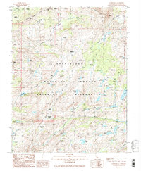
1990 Map of Cooper Peak
USGS Topo · Published 1990About this map
Emigrant Wilderness and the Stanislaus National Forest define this high-altitude landscape in the Sierra Nevada. The terrain is marked by the sharp rise of Cooper Peak and Castle Rock, which guard the passage at Eagle Pass. This map illustrates a complex network of high-country meadows and glaciated basins, where features like Horse and Cow Meadow, Coyote Meadows, and Whitesides Meadow provided seasonal forage and vital landmarks for early travelers.
Find a feature on this map
60 named features on this map. Tap any name to fly to it.
Don’t see what you’re looking for? This feature index may not catch every label — zoom into the map to look around manually.
Map Details
Editions of this 1990 Cooper Peak Map
2 editions found
Other maps of this area

1896 · Dardanelles
USGS Topo · 1:125,000

1898 · Dardanelles
USGS Topo · 1:125,000

1948 · Walker Lake
USGS Topo · 1:250,000

1956 · Dardanelles Cone
USGS Topo · 1:62,500

1956 · Pinecrest
USGS Topo · 1:62,500

1956 · Sonora Pass
USGS Topo · 1:62,500
1956 · Tower Peak
USGS Topo · 1:62,500

1957 · Walker Lake
USGS Topo · 1:250,000

1962 · Walker Lake
USGS Topo · 1:250,000

1964 · Walker Lake
USGS Topo · 1:250,000