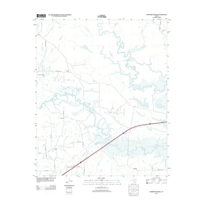
2012 Map of Coopers Chapel
USGS Topo · Published 2012About this map
Sulphur River and its complex network of sloughs and lakes dominate this corner of Northeast Texas. The landscape is defined by the winding course of Long Lake Slough, which feeds a series of water bodies including Blue Lake, Grassy Lake, and Lost Lake. In the southern portion of the quadrangle, the terrain is shaped by the drainage of White Oak Cr and Smackover Cr. The small community of Coopers Chapel serves as a local landmark, while historical footprints are preserved at Evergreen Cem and Mt Moriah Cem. Industrial activity is evident in the northwest at the Pewitt Ranch Oil Field. The modern corridor of Interstate 30 cuts through the southern half, contrasting with the dense network of rural county roads like Union Chapel Rd that connect the area's older settlements and family farmsteads.
Find a feature on this map
48 named features on this map. Tap any name to fly to it.
Don’t see what you’re looking for? This feature index may not catch every label — zoom into the map to look around manually.
Map Details
Editions of this 2012 Coopers Chapel Map
This is the sole edition of this map. No revisions or reprints were ever made.
Other maps of this area

1914 · Daingerfield
USGS Topo · 1:62,500

1930 · Bassett
USGS Topo · 1:62,500

1953 · Texarkana
USGS Topo · 1:250,000

1956 · Texarkana
USGS Topo · 1:250,000

1964 · Wilkinson
USGS Topo · 1:24,000

1965 · Lydia
USGS Topo · 1:24,000
1965 · Hodgson
USGS Topo · 1:24,000

1965 · Dalby Springs
USGS Topo · 1:24,000

1965 · Mount Pleasant
USGS Topo · 1:24,000
1965 · Boxelder
USGS Topo · 1:24,000