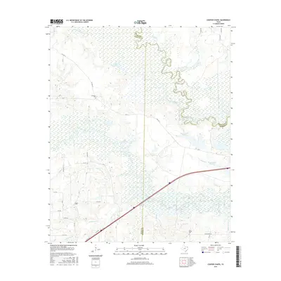
2016 Map of Coopers Chapel
USGS Topo · Published 2016About this map
Sulphur River and the complex wetlands of the Texas bottomlands define this landscape along the border of Titus, Red River, and Morris counties. The river meanders through a dense network of sloughs and lakes, including Long Lake Slough, Grassy Lake, and Lost Lake, highlighting the natural drainage patterns that have historically shaped local land use. To the south, the terrain transitions into more established upland areas where rural communities like Coopers Chapel, Evergreen, and Mount Moriah are situated. These settlements are often centered around local landmarks such as Evergreen Cem and Mount Moriah Cem, which serve as vital points of interest for genealogists and local historians. The presence of White Oak Creek and numerous smaller tributaries like Smackover Cr and Snake Cr further illustrates the intricate water systems that supported these Northeast Texas communities into the early 21st century.
Find a feature on this map
55 named features on this map. Tap any name to fly to it.
Don’t see what you’re looking for? This feature index may not catch every label — zoom into the map to look around manually.
Map Details
Editions of this 2016 Coopers Chapel Map
This is the sole edition of this map. No revisions or reprints were ever made.
Other maps of this area

1914 · Daingerfield
USGS Topo · 1:62,500

1930 · Bassett
USGS Topo · 1:62,500

1953 · Texarkana
USGS Topo · 1:250,000

1956 · Texarkana
USGS Topo · 1:250,000

1964 · Wilkinson
USGS Topo · 1:24,000

1965 · Lydia
USGS Topo · 1:24,000
1965 · Hodgson
USGS Topo · 1:24,000

1965 · Dalby Springs
USGS Topo · 1:24,000

1965 · Mount Pleasant
USGS Topo · 1:24,000
1965 · Boxelder
USGS Topo · 1:24,000