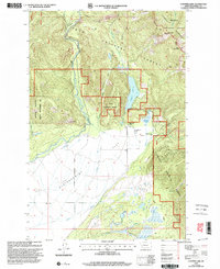
1999 Map of Coopers Lake
USGS Topo · Published 2003About this map
Kleinschmidt Flat dominates the southern landscape of this 1990s revision, where the North Fork Blackfoot River meanders through the broad valley floor. The map reflects a classic Montana ranching and forest-service landscape, highlighted by the White Tail Ranch and Copenhagen Ranch located near the eastern foothills. This transition from the flatlands to the mountains is marked by Coopers Lake and the dense wilderness of the Lolo National Forest and Helena National Forest.
Find a feature on this map
40 named features on this map. Tap any name to fly to it.
Don’t see what you’re looking for? This feature index may not catch every label — zoom into the map to look around manually.
Map Details
Editions of this 1999 Coopers Lake Map
This is the sole edition of this map. No revisions or reprints were ever made.
Other maps of this area

1889 · Helena
USGS Topo · 1:250,000

1893 · Helena
USGS Topo · 1:250,000

1899 · Helena
USGS Topo · 1:250,000

1902 · Ovando
USGS Topo · 1:125,000

1903 · Coopers Lake
USGS Topo · 1:125,000

1903 · Helena
USGS Topo · 1:250,000

1905 · Ovando
USGS Topo · 1:125,000

1919 · Drummond
USGS Topo · 1:125,000

1921 · Drummond
USGS Topo · 1:125,000

1947 · Butte
USGS Topo · 1:250,000