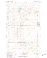
1961 Map of Cooperstown West
USGS Topo · Published 1984About this map
The eastern edge of Cooperstown serves as the primary hub of activity in this North Dakota landscape, where the Burlington Northern railroad corridor dictates the regional orientation. Extending across the townships of Clearfield, Helena, Cooperstown, and Ball Hill, the map reveals a prairie environment defined by depressions and scattered water bodies, most notably Lake Five. The landscape is dotted with several Gravel Pits, signaling the local extraction industries that supported road and rail construction during the mid-20th century. To the south, the small settlement of Shepard marks a secondary point along the rail line, providing a focused view of rural life and transit in Griggs County during the early 1960s. This survey, later updated with photorevisions, documents the steady agricultural and industrial footprint of the High Plains.
Find a feature on this map
10 named features on this map. Tap any name to fly to it.
Don’t see what you’re looking for? This feature index may not catch every label — zoom into the map to look around manually.
Map Details
Editions of this 1961 Cooperstown West Map
2 editions found
Other maps of this area

1952 · New Rockford
USGS Topo · 1:250,000

1956 · New Rockford
USGS Topo · 1:250,000

1961 · Binford
USGS Topo · 1:24,000

1961 · Cooperstown East
USGS Topo · 1:24,000

1961 · Jessie
USGS Topo · 1:24,000

1961 · Revere
USGS Topo · 1:24,000

1961 · Hannaford
USGS Topo · 1:24,000

1961 · Cooperstown West
USGS Topo · 1:24,000

1961 · Sutton NE
USGS Topo · 1:24,000

1961 · Karnak
USGS Topo · 1:24,000