
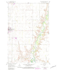
1961 Map of Cooperstown East
USGS Topo · Published 1963About this map
Cooperstown serves as the focal point of this North Dakota landscape, situated at the edge of a vast prairie plateau that drops into the meandering valley of the Sheyenne River. The 1961 field check captures the area just as the southern reach of the river was transformed into Lake Ashtabula behind the Ueland Dam. This survey provides a clear look at local infrastructure during the early 1960s, from the Fairground and Cooperstown Airport on the town's outskirts to the rural townships of Washburn and Sverdrup. Genealogists will find the locations of Cooperstown Cem and St George Cem clearly marked, alongside various Gaging Stations and Gravel Pit operations that define the local economy and river management of the era.
Find a feature on this map
15 named features on this map. Tap any name to fly to it.
Don’t see what you’re looking for? This feature index may not catch every label — zoom into the map to look around manually.
Map Details
Editions of this 1961 Cooperstown East Map
2 editions found
Other maps of this area

1952 · Grand Forks
USGS Topo · 1:250,000

1952 · New Rockford
USGS Topo · 1:250,000

1956 · New Rockford
USGS Topo · 1:250,000

1956 · Grand Forks
USGS Topo · 1:250,000

1961 · Jessie
USGS Topo · 1:24,000

1961 · Hannaford
USGS Topo · 1:24,000

1961 · Cooperstown West
USGS Topo · 1:24,000

1961 · Karnak
USGS Topo · 1:24,000

1966 · Grand Forks
USGS Topo · 1:250,000
1967 · Kloten SE
USGS Topo · 1:24,000