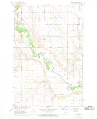
1967 Map of Kloten SE
USGS Topo · Published 1969About this map
The Sheyenne River creates a meandering path through Griggs County, defining the rural character of the townships of Lenora, Romness, and Tyrol. This mid-century landscape is anchored by local landmarks such as Pilot Mound and a series of community churches that suggest the social centers of the era. The mapping includes Ottawa Ch in the north and Ringsaker Ch to the south, while the Romness Ch sits near the riverbanks alongside a local Cem. Numerous Gravel Pits follow the river valley, indicating the importance of local materials for road building and industry. The presence of Pickerel Lake Creek and scattered marshes reflects the prairie pothole topography common to this region of North Dakota during the late 1960s.
Find a feature on this map
12 named features on this map. Tap any name to fly to it.
Don’t see what you’re looking for? This feature index may not catch every label — zoom into the map to look around manually.
Map Details
Editions of this 1967 Kloten SE Map
This is the sole edition of this map. No revisions or reprints were ever made.
Other maps of this area

1952 · Grand Forks
USGS Topo · 1:250,000

1952 · New Rockford
USGS Topo · 1:250,000

1956 · New Rockford
USGS Topo · 1:250,000

1956 · Grand Forks
USGS Topo · 1:250,000

1961 · Kloten NW
USGS Topo · 1:24,000

1961 · Cooperstown East
USGS Topo · 1:24,000

1961 · Jessie
USGS Topo · 1:24,000

1961 · Cooperstown West
USGS Topo · 1:24,000

1966 · Grand Forks
USGS Topo · 1:250,000
1967 · Sharon
USGS Topo · 1:24,000