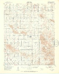
1949 Map of Cooperton
USGS Topo · Published 1953About this map
The Rainy Mountain Indian School and its associated Reservation land dominate the northern plains of this Kiowa County landscape at the close of the 1940s. Centered on the small settlement of Cooperton, the map illustrates a transition from the agricultural lowlands surrounding Rainy Mountain Creek to the stony heights of the Wichita Mountains in the southeast. This southern portion is defined by the Wichita Wildlife Refuge, where peaks like Mt Pinchot and Baker Peak rise sharply above the Glen Mountains. Local history is preserved in the location of the Rainy Mountain Ch and the Union Dale Cem, while a Gold Mine (Abandoned) on the western edge of the mountains points to earlier prospecting efforts. The San Francisco railroad line clips the southwestern corner, providing a vital connection for this rural Oklahoma district.
Find a feature on this map
43 named features on this map. Tap any name to fly to it.
Don’t see what you’re looking for? This feature index may not catch every label — zoom into the map to look around manually.
Map Details
Editions of this 1949 Cooperton Map
2 editions found
Other maps of this area

1937 · Cache
USGS Topo · 1:48,000

1937 · Quanah Mountain
USGS Topo · 1:24,000

1942 · Cache
USGS Topo · 1:62,500

1949 · Cooperton
USGS Topo · 1:62,500

1949 · Quanah Mountain
USGS Topo · 1:24,000

1950 · Snyder
USGS Topo · 1:62,500

1950 · Saddle Mountain
USGS Topo · 1:62,500

1955 · Lawton
USGS Topo · 1:250,000

1955 · Clinton
USGS Topo · 1:250,000

1956 · Glen Mountains
USGS Topo · 1:24,000