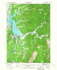
1942 Map of Coos Bay
USGS Topo · Published 1967About this map
Industrial activity along the Coos River and its intricate tidal sloughs defines this 1942 survey. The landscape is characterized by the complex confluence of the Millicoma River and the South Fork Millicoma River, where the timber and coal economies left their mark. Notable extractive sites like the inactive Libby Coal Mine and the Southport Coal Mine are documented alongside the Southern Pacific railroad line, which served the growing waterfront hubs of North Bend and Coos Bay.
Find a feature on this map
92 named features on this map. Tap any name to fly to it.
Don’t see what you’re looking for? This feature index may not catch every label — zoom into the map to look around manually.
Map Details
Editions of this 1942 Coos Bay Map
2 editions found
Other maps of this area

1896 · Coos Bay
USGS Topo · 1:125,000

1898 · Coos Bay
USGS Topo · 1:125,000

1900 · Coos Bay
USGS Topo · 1:125,000

1923 · Reedsport
USGS Topo · 1:62,500

1928 · Sitkum
USGS Topo · 1:125,000

1942 · Reedsport
USGS Topo · 1:62,500

1942 · Empire
USGS Topo · 1:62,500

1942 · Coquille
USGS Topo · 1:62,500

1942 · Coos Bay
USGS Topo · 1:62,500

1943 · Bandon
USGS Topo · 1:62,500