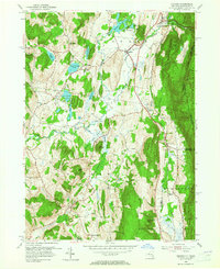
1953 Map of Copake
USGS Topo · Published 1965About this map
The New York Central rail line carves through this Columbia County landscape, connecting the clustered hamlets of Copake Falls, Copake, and Boston Corner. This 1953 field-checked study reveals a rural economy shaped by a complex network of water and terrain, where the Roeliff Jansen Kill and Punch Brook navigate the lowlands around the massive Drowned Lands Swamp. To the east, the steep rise of Washburn Mountain and Alander Mtn marks the transition into Mount Washington State Park at the Massachusetts border.
Find a feature on this map
41 named features on this map. Tap any name to fly to it.
Don’t see what you’re looking for? This feature index may not catch every label — zoom into the map to look around manually.
Map Details
Editions of this 1953 Copake Map
4 editions found
Other maps of this area

1885 · Sheffield
USGS Topo · 1:62,500

1888 · Sheffield
USGS Topo · 1:62,500

1891 · Sheffield
USGS Topo · 1:62,500

1892 · Cornwall
USGS Topo · 1:62,500

1893 · Sheffield
USGS Topo · 1:62,500

1893 · Cornwall
USGS Topo · 1:62,500

1897 · Sheffield
USGS Topo · 1:62,500

1899 · Housatonic
USGS Topo · 1:125,000

1899 · Millbrook
USGS Topo · 1:62,500

1900 · Housatonic
USGS Topo · 1:125,000