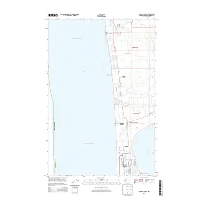
2014 Map of Copalis Beach
USGS Topo · Published 2014About this map
The coastal communities of Ocean Shores and Copalis Beach are mapped here along a narrow strip of land between the Pacific Ocean and the Humptulips River estuary. This 2014 survey reveals a landscape defined by seasonal tourism and residential expansion along the Grays Harbor County shoreline. The southern portion of the map is dominated by the grid of Ocean Shores, where a network of canals and streets such as Anchor Ave NW surround Duck Lake.
Find a feature on this map
53 named features on this map. Tap any name to fly to it.
Don’t see what you’re looking for? This feature index may not catch every label — zoom into the map to look around manually.
Map Details
Editions of this 2014 Copalis Beach Map
This is the sole edition of this map. No revisions or reprints were ever made.
Other maps of this area

1938 · Moclips
USGS Topo · 1:62,500

1941 · Moclips
USGS Topo · 1:62,500

1941 · Grayland
USGS Topo · 1:62,500

1943 · Copalis Beach
USGS Topo · 1:250,000

1951 · Copalis Beach
USGS Topo · 1:250,000

1955 · Point Brown
USGS Topo · 1:24,000

1955 · Carlisle
USGS Topo · 1:24,000

1955 · Copalis Beach
USGS Topo · 1:24,000
1955 · Moclips
USGS Topo · 1:24,000

1956 · Copalis Crossing
USGS Topo · 1:24,000