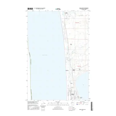
2017 Map of Copalis Beach
USGS Topo · Published 2017About this map
Pacific Ocean swells meet a narrow, densely developed coastal strip in this detailed look at Grays Harbor County's northern peninsula. The southern portion of the sheet is dominated by the planned grid of Ocean Shores, where a complex network of residential streets like Magellan Ave NE and Cardinal Ave NE surrounds the elongated Duck Lake. This area contrasts with the more linear, highway-oriented development to the north, where smaller clusters such as Oyehut, Sampson, and Ocean City follow the coastline toward the mouth of the Copalis River. Transportation and recreation are central to the landscape, evidenced by the Ocean Shores Municipal Airport and Hogan's Corner Airport, alongside the numerous public access points to the beaches. Inland, the terrain softens into the wetlands of North Bay and the drainage of Cranberry Creek, illustrating the delicate balance between the maritime environment and the communities built upon it.
Find a feature on this map
41 named features on this map. Tap any name to fly to it.
Don’t see what you’re looking for? This feature index may not catch every label — zoom into the map to look around manually.
Map Details
Editions of this 2017 Copalis Beach Map
This is the sole edition of this map. No revisions or reprints were ever made.
Other maps of this area

1938 · Moclips
USGS Topo · 1:62,500

1941 · Moclips
USGS Topo · 1:62,500

1941 · Grayland
USGS Topo · 1:62,500

1943 · Copalis Beach
USGS Topo · 1:250,000

1951 · Copalis Beach
USGS Topo · 1:250,000

1955 · Point Brown
USGS Topo · 1:24,000

1955 · Carlisle
USGS Topo · 1:24,000

1955 · Copalis Beach
USGS Topo · 1:24,000
1955 · Moclips
USGS Topo · 1:24,000

1956 · Copalis Crossing
USGS Topo · 1:24,000