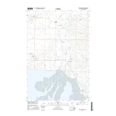
2017 Map of Copalis Crossing
USGS Topo · Published 2017About this map
Humptulips River and its intricate network of sloughs dictate the landscape of this coastal Washington region, where the river meets the tide at the Campbell Slough Channel. Small rural settlements like Copalis Crossing, Newton, and Tulips are scattered along the valley floor, connected by roads such as Kirkpatrick Rd and Powell Rd. The map illustrates a transitional environment between the higher elevations of Langley Hill and Saddle Hill and the complex wetlands where Jessie Slough and Kurtz Slough feed into the estuary. To the south, the community of Gray Gables sits near the winding paths of Chenois Creek and Grass Creek. The presence of numerous Pvt Logging Rd labels suggests the ongoing importance of the timber industry in shaping the local infrastructure and access points throughout the late twentieth century.
Find a feature on this map
37 named features on this map. Tap any name to fly to it.
Don’t see what you’re looking for? This feature index may not catch every label — zoom into the map to look around manually.
Map Details
Editions of this 2017 Copalis Crossing Map
This is the sole edition of this map. No revisions or reprints were ever made.
Other maps of this area

1938 · Moclips
USGS Topo · 1:62,500

1941 · Moclips
USGS Topo · 1:62,500

1941 · Grayland
USGS Topo · 1:62,500

1943 · Humptulips
USGS Topo · 1:62,500

1943 · Copalis Beach
USGS Topo · 1:250,000

1951 · Copalis Beach
USGS Topo · 1:250,000

1953 · Hoquiam
USGS Topo · 1:250,000

1955 · Humptulips
USGS Topo · 1:62,500

1955 · Point Brown
USGS Topo · 1:24,000

1955 · Carlisle
USGS Topo · 1:24,000